
Altitude: 150m
Distance from Beirut: 80 km
Distance from Tripoli: 7 km
Latitude: 34.3997
Lat (DMS): 34° 23' 59N
Longitude: 35.8933
Long (DMS): 35° 53' 36E
Time zone (est.): UTC+2(+3DT)
Approximate population for 7 km radius from this point: 100567
Roads to get there:
Beirut – Tripoli – Zgharta
or Via: Chekka – Kfarhazir – Bchennine – Besebeel – Zgharta
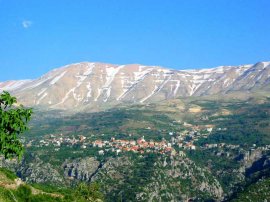
The center of the region is Zgharta that holds around 40.000 residents. The name Zgharta (Zigorta) originates from the Ammourian language, referring to the “fortified place”. Around 200 B.C, it was colonized. The church of Virgin Mary in Ehden was built using the same stones of the ruined fortress of Zgharta.
Zgharta is located on a hill In between two rivers, Rachine and Jouiit that enriches the land with orange and olives cultivation.
also


 Pierre Douaihy